


Somme-Crécy-Les Vieux Chênes

nicolas54230
Gebruiker
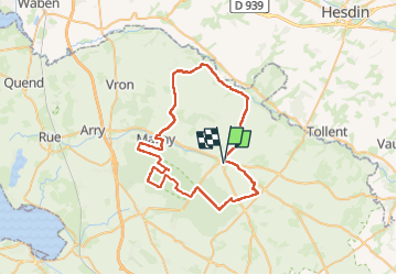

Lengte
52 km

Max. hoogte
96 m

Positief hoogteverschil
415 m
Km-Effort
57 km

Min. hoogte
9 m

Negatief hoogteverschil
419 m
Boucle
Ja
Datum van aanmaak :
2025-04-11 06:47:06.844
Laatste wijziging :
2025-04-11 06:48:00.451
0m
Moeilijkheid : Medium

Gratisgps-wandelapplicatie
 SityTrail
IGN / Geografische instituten
SityTrail Plus
De wereld gaat voor u open
Over ons
Tocht Fietstoerisme van 52 km beschikbaar op Hauts-de-France, Somme, Crécy-en-Ponthieu. Deze tocht wordt voorgesteld door nicolas54230.
Plaatsbepaling
Land:
France
Regio :
Hauts-de-France
Departement/Provincie :
Somme
Gemeente :
Crécy-en-Ponthieu
Locatie:
Crécy-en-Ponthieu
Vertrek:(Dec)
Vertrek:(UTM)
420543 ; 5567222 (31U) N.
Opmerkingen