


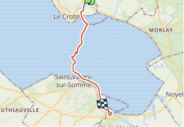
Baie de Somme

jpgo73
Gebruiker

Lengte
7,3 km

Max. hoogte
6 m

Positief hoogteverschil
16 m
Km-Effort
7,5 km

Min. hoogte
-1 m

Negatief hoogteverschil
18 m
Boucle
Neen
Datum van aanmaak :
2025-04-21 06:53:30.114
Laatste wijziging :
2025-04-21 11:30:12.29
4h36
Moeilijkheid : Medium

Gratisgps-wandelapplicatie
 SityTrail
IGN / Geografische instituten
SityTrail Plus
De wereld gaat voor u open
Over ons
Tocht Stappen van 7,3 km beschikbaar op Hauts-de-France, Somme, Le Crotoy. Deze tocht wordt voorgesteld door jpgo73.
Plaatsbepaling
Land:
France
Regio :
Hauts-de-France
Departement/Provincie :
Somme
Gemeente :
Le Crotoy
Locatie:
Unknown
Vertrek:(Dec)
Vertrek:(UTM)
402560 ; 5563846 (31U) N.
Opmerkingen