


22 La Forestière circuit VTT n22 rouge

nicolas54230
Gebruiker

Lengte
26 km

Max. hoogte
1430 m

Positief hoogteverschil
789 m
Km-Effort
36 km

Min. hoogte
1034 m

Negatief hoogteverschil
788 m
Boucle
Ja
Datum van aanmaak :
2025-04-24 17:53:44.465
Laatste wijziging :
2025-04-24 17:55:00.651
2h31
Moeilijkheid : Moeilijk

Gratisgps-wandelapplicatie
 SityTrail
IGN / Geografische instituten
SityTrail Plus
De wereld gaat voor u open
Over ons
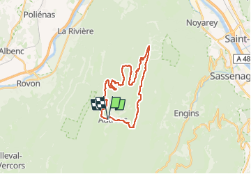
Tocht Mountainbike van 26 km beschikbaar op Auvergne-Rhône-Alpes, Isère, Autrans-Méaudre en Vercors. Deze tocht wordt voorgesteld door nicolas54230.
Plaatsbepaling
Land:
France
Regio :
Auvergne-Rhône-Alpes
Departement/Provincie :
Isère
Gemeente :
Autrans-Méaudre en Vercors
Locatie:
Autrans
Vertrek:(Dec)
Vertrek:(UTM)
699560 ; 5005637 (31T) N.
Opmerkingen