


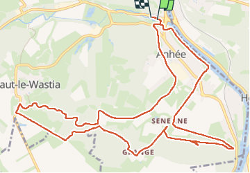
250428 Anhée

guy284
Gebruiker

Lengte
14,3 km

Max. hoogte
247 m

Positief hoogteverschil
324 m
Km-Effort
18,6 km

Min. hoogte
85 m

Negatief hoogteverschil
322 m
Boucle
Ja
Datum van aanmaak :
2025-04-28 12:02:29.706
Laatste wijziging :
2025-04-28 14:58:56.518
2h48
Moeilijkheid : Medium

Gratisgps-wandelapplicatie
 SityTrail
IGN / Geografische instituten
SityTrail Plus
De wereld gaat voor u open
Over ons
Tocht Stappen van 14,3 km beschikbaar op Wallonië, Namen, Anhée. Deze tocht wordt voorgesteld door guy284.
Plaatsbepaling
Land:
Belgium
Regio :
Wallonië
Departement/Provincie :
Namen
Gemeente :
Anhée
Locatie:
Unknown
Vertrek:(Dec)
Vertrek:(UTM)
633420 ; 5575409 (31U) N.
Opmerkingen