


Cicé Ranch 1

thle
Gebruiker
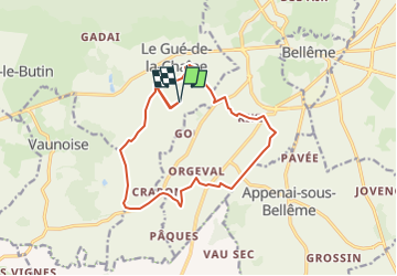

Lengte
13,9 km

Max. hoogte
211 m

Positief hoogteverschil
217 m
Km-Effort
16,8 km

Min. hoogte
127 m

Negatief hoogteverschil
217 m
Boucle
Ja
Datum van aanmaak :
2025-05-08 10:22:04.516
Laatste wijziging :
2025-05-08 10:22:08.029
2h12
Moeilijkheid : Gemakkelijk

Gratisgps-wandelapplicatie
 SityTrail
IGN / Geografische instituten
SityTrail Plus
De wereld gaat voor u open
Over ons
Tocht Paardrijden van 13,9 km beschikbaar op Normandië, Orne, Belforêt-en-Perche. Deze tocht wordt voorgesteld door thle.
Plaatsbepaling
Land:
France
Regio :
Normandië
Departement/Provincie :
Orne
Gemeente :
Belforêt-en-Perche
Locatie:
Le Gué-de-la-Chaîne
Vertrek:(Dec)
Vertrek:(UTM)
316549 ; 5359814 (31U) N.
Opmerkingen