


celles version 2

ISAGIL
Gebruiker
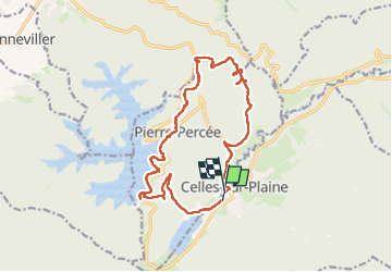

Lengte
15,9 km

Max. hoogte
564 m

Positief hoogteverschil
484 m
Km-Effort
22 km

Min. hoogte
306 m

Negatief hoogteverschil
484 m
Boucle
Ja
Datum van aanmaak :
2025-05-17 07:15:05.155
Laatste wijziging :
2025-05-17 14:01:07.758
6h44
Moeilijkheid : Zeer moeilijk

Gratisgps-wandelapplicatie
 SityTrail
IGN / Geografische instituten
SityTrail Plus
De wereld gaat voor u open
Over ons
Tocht Stappen van 15,9 km beschikbaar op Grand Est, Vogezen, Celles-sur-Plaine. Deze tocht wordt voorgesteld door ISAGIL.
Beschrijving
Pierre percee
Plaatsbepaling
Land:
France
Regio :
Grand Est
Departement/Provincie :
Vogezen
Gemeente :
Celles-sur-Plaine
Locatie:
Unknown
Vertrek:(Dec)
Vertrek:(UTM)
348174 ; 5368811 (32U) N.
Opmerkingen