


rando cham joinville cham modifiée

Cat'April
Gebruiker
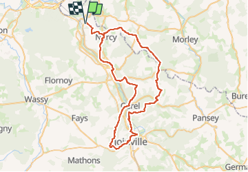

Lengte
67 km

Max. hoogte
346 m

Positief hoogteverschil
1167 m
Km-Effort
83 km

Min. hoogte
162 m

Negatief hoogteverschil
1167 m
Boucle
Ja
Datum van aanmaak :
2025-06-02 13:26:42.432
Laatste wijziging :
2025-06-02 13:26:52.444
10h52
Moeilijkheid : Zeer moeilijk

Gratisgps-wandelapplicatie
 SityTrail
IGN / Geografische instituten
SityTrail Plus
De wereld gaat voor u open
Over ons
Tocht Paardrijden van 67 km beschikbaar op Grand Est, Haute-Marne, Chamouilley. Deze tocht wordt voorgesteld door Cat'April.
Plaatsbepaling
Land:
France
Regio :
Grand Est
Departement/Provincie :
Haute-Marne
Gemeente :
Chamouilley
Locatie:
Unknown
Vertrek:(Dec)
Vertrek:(UTM)
651027 ; 5385056 (31U) N.
Opmerkingen