


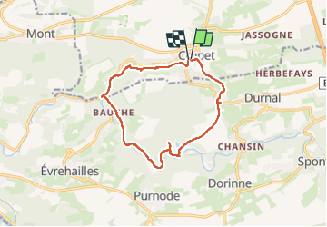
Crupet Boucle Herleuvau-Bocq-Bauche 12.5km

thomarche
Gebruiker

Lengte
14,7 km

Max. hoogte
287 m

Positief hoogteverschil
374 m
Km-Effort
19,7 km

Min. hoogte
118 m

Negatief hoogteverschil
380 m
Boucle
Ja
Datum van aanmaak :
2025-06-06 09:15:10.0
Laatste wijziging :
2025-06-07 13:30:07.163
6h01
Moeilijkheid : Onbekend

Gratisgps-wandelapplicatie
 SityTrail
IGN / Geografische instituten
SityTrail Plus
De wereld gaat voor u open
Over ons
Tocht Stappen van 14,7 km beschikbaar op Wallonië, Namen, Assesse. Deze tocht wordt voorgesteld door thomarche.
Beschrijving
Belle boucle suivant GRP, puis Bocq, puis de nouveau Variante GRP Bauche-Crupet.
Plaatsbepaling
Land:
Belgium
Regio :
Wallonië
Departement/Provincie :
Namen
Gemeente :
Assesse
Locatie:
Unknown
Vertrek:(Dec)
Vertrek:(UTM)
639339 ; 5579096 (31U) N.
Opmerkingen