


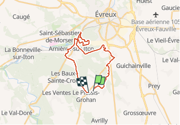
Evreux sud

fredtruc27
Gebruiker

Lengte
24 km

Max. hoogte
159 m

Positief hoogteverschil
280 m
Km-Effort
28 km

Min. hoogte
70 m

Negatief hoogteverschil
275 m
Boucle
Neen
Datum van aanmaak :
2015-07-23 00:00:00.0
Laatste wijziging :
2015-07-23 00:00:00.0
1h43
Moeilijkheid : Gemakkelijk

Gratisgps-wandelapplicatie
 SityTrail
IGN / Geografische instituten
SityTrail Plus
De wereld gaat voor u open
Over ons
Tocht Mountainbike van 24 km beschikbaar op Normandië, Eure, Le Plessis-Grohan. Deze tocht wordt voorgesteld door fredtruc27.
Foto's

Plaatsbepaling
Land:
France
Regio :
Normandië
Departement/Provincie :
Eure
Gemeente :
Le Plessis-Grohan
Locatie:
Unknown
Vertrek:(Dec)
Vertrek:(UTM)
363360 ; 5424360 (31U) N.
Opmerkingen