


Maillen FondsLustin BoisDave SartBernard

thomarche
Gebruiker
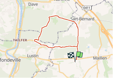

Lengte
13,2 km

Max. hoogte
280 m

Positief hoogteverschil
320 m
Km-Effort
17,4 km

Min. hoogte
128 m

Negatief hoogteverschil
321 m
Boucle
Ja
Datum van aanmaak :
2025-06-13 10:52:39.0
Laatste wijziging :
2025-06-13 15:09:30.517
3h33
Moeilijkheid : Gemakkelijk

Gratisgps-wandelapplicatie
 SityTrail
IGN / Geografische instituten
SityTrail Plus
De wereld gaat voor u open
Over ons
Tocht Stappen van 13,2 km beschikbaar op Wallonië, Namen, Assesse. Deze tocht wordt voorgesteld door thomarche.
Beschrijving
Boucle sympa tout dans les bois sauf calme Fonds de Lustin
Plaatsbepaling
Land:
Belgium
Regio :
Wallonië
Departement/Provincie :
Namen
Gemeente :
Assesse
Locatie:
Unknown
Vertrek:(Dec)
Vertrek:(UTM)
638156 ; 5582137 (31U) N.
Opmerkingen