


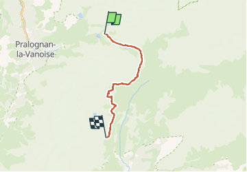
REFUGE COL VANOISE/REFUGE ARPONT ( 450 m d+, 655 m d-).

DUCLUZEAU
Gebruiker

Lengte
14,1 km

Max. hoogte
2580 m

Positief hoogteverschil
445 m
Km-Effort
21 km

Min. hoogte
2297 m

Negatief hoogteverschil
654 m
Boucle
Neen
Datum van aanmaak :
2025-06-16 14:20:11.394
Laatste wijziging :
2025-06-16 14:22:10.953
4h43
Moeilijkheid : Moeilijk

Gratisgps-wandelapplicatie
 SityTrail
IGN / Geografische instituten
SityTrail Plus
De wereld gaat voor u open
Over ons
Tocht Stappen van 14,1 km beschikbaar op Auvergne-Rhône-Alpes, Savoie, Pralognan-la-Vanoise. Deze tocht wordt voorgesteld door DUCLUZEAU.
Plaatsbepaling
Land:
France
Regio :
Auvergne-Rhône-Alpes
Departement/Provincie :
Savoie
Gemeente :
Pralognan-la-Vanoise
Locatie:
Unknown
Vertrek:(Dec)
Vertrek:(UTM)
327083 ; 5028895 (32T) N.
Opmerkingen