


OR-8104320--Lay-Saint-Christophe:Les 2 étangs (11 kms)

noelphil
Gebruiker
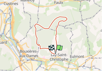

Lengte
11,4 km

Max. hoogte
362 m

Positief hoogteverschil
261 m
Km-Effort
14,9 km

Min. hoogte
207 m

Negatief hoogteverschil
259 m
Boucle
Ja
Datum van aanmaak :
2025-06-23 05:43:10.605
Laatste wijziging :
2025-06-23 05:43:36.236
3h22
Moeilijkheid : Moeilijk

Gratisgps-wandelapplicatie
 SityTrail
IGN / Geografische instituten
SityTrail Plus
De wereld gaat voor u open
Over ons
Tocht Stappen van 11,4 km beschikbaar op Grand Est, Meurthe-et-Moselle, Lay-Saint-Christophe. Deze tocht wordt voorgesteld door noelphil.
Plaatsbepaling
Land:
France
Regio :
Grand Est
Departement/Provincie :
Meurthe-et-Moselle
Gemeente :
Lay-Saint-Christophe
Locatie:
Unknown
Vertrek:(Dec)
Vertrek:(UTM)
293956 ; 5403549 (32U) N.
Opmerkingen