


Vercors-La Chapelle-Combe Laval

nicolas54230
Gebruiker
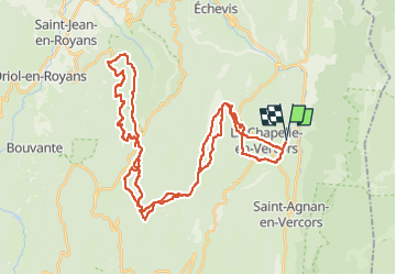

Lengte
52 km

Max. hoogte
1357 m

Positief hoogteverschil
1616 m
Km-Effort
73 km

Min. hoogte
821 m

Negatief hoogteverschil
1616 m
Boucle
Ja
Datum van aanmaak :
2025-06-28 16:13:19.286
Laatste wijziging :
2025-06-28 16:14:45.07
5h05
Moeilijkheid : Zeer moeilijk

Gratisgps-wandelapplicatie
 SityTrail
IGN / Geografische instituten
SityTrail Plus
De wereld gaat voor u open
Over ons
Tocht Mountainbike van 52 km beschikbaar op Auvergne-Rhône-Alpes, Drôme, La Chapelle-en-Vercors. Deze tocht wordt voorgesteld door nicolas54230.
Plaatsbepaling
Land:
France
Regio :
Auvergne-Rhône-Alpes
Departement/Provincie :
Drôme
Gemeente :
La Chapelle-en-Vercors
Locatie:
Unknown
Vertrek:(Dec)
Vertrek:(UTM)
691551 ; 4982279 (31T) N.
Opmerkingen