


Fiz J 3

DUCLUZEAU
Gebruiker

Lengte
12,9 km

Max. hoogte
2658 m

Positief hoogteverschil
1066 m
Km-Effort
27 km

Min. hoogte
1870 m

Negatief hoogteverschil
895 m
Boucle
Neen
Datum van aanmaak :
2025-07-03 11:47:31.971
Laatste wijziging :
2025-07-03 11:47:34.933
6h01
Moeilijkheid : Zeer moeilijk

Gratisgps-wandelapplicatie
 SityTrail
IGN / Geografische instituten
SityTrail Plus
De wereld gaat voor u open
Over ons
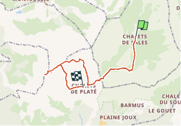
Tocht Stappen van 12,9 km beschikbaar op Auvergne-Rhône-Alpes, Haute-Savoie, Sixt-Fer-à-Cheval. Deze tocht wordt voorgesteld door DUCLUZEAU.
Plaatsbepaling
Land:
France
Regio :
Auvergne-Rhône-Alpes
Departement/Provincie :
Haute-Savoie
Gemeente :
Sixt-Fer-à-Cheval
Locatie:
Unknown
Vertrek:(Dec)
Vertrek:(UTM)
325967 ; 5095349 (32T) N.
Opmerkingen