


boucle pepoiri petoumier

aris
Gebruiker
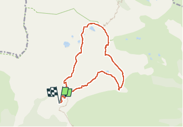

Lengte
8,2 km

Max. hoogte
2658 m

Positief hoogteverschil
681 m
Km-Effort
17,3 km

Min. hoogte
2031 m

Negatief hoogteverschil
679 m
Boucle
Ja
Datum van aanmaak :
2025-07-07 06:46:54.875
Laatste wijziging :
2025-07-07 11:13:15.128
4h25
Moeilijkheid : Medium

Gratisgps-wandelapplicatie
 SityTrail
IGN / Geografische instituten
SityTrail Plus
De wereld gaat voor u open
Over ons
Tocht Stappen van 8,2 km beschikbaar op Provence-Alpes-Côte d'Azur, Alpes-Maritimes, Valdeblore. Deze tocht wordt voorgesteld door aris.
Plaatsbepaling
Land:
France
Regio :
Provence-Alpes-Côte d'Azur
Departement/Provincie :
Alpes-Maritimes
Gemeente :
Valdeblore
Locatie:
Unknown
Vertrek:(Dec)
Vertrek:(UTM)
354867 ; 4884431 (32T) N.
Opmerkingen