


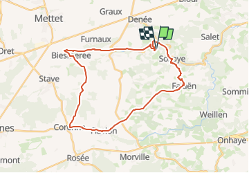
MAREDSOUS ... à Vtt

GerardBouche
Gebruiker

Lengte
29 km

Max. hoogte
300 m

Positief hoogteverschil
477 m
Km-Effort
35 km

Min. hoogte
148 m

Negatief hoogteverschil
473 m
Boucle
Ja
Datum van aanmaak :
2025-07-19 07:42:01.401
Laatste wijziging :
2025-07-21 06:37:20.524
2h25
Moeilijkheid : Gemakkelijk

Gratisgps-wandelapplicatie
 SityTrail
IGN / Geografische instituten
SityTrail Plus
De wereld gaat voor u open
Over ons
Tocht Mountainbike van 29 km beschikbaar op Wallonië, Namen, Anhée. Deze tocht wordt voorgesteld door GerardBouche.
Beschrijving
Depuis l'Abbaye de Maredsous ... par l'Abbaye de Maredret, Ermeton-sur-Biert, Biesmerée, Corenne, Flavion et Falaën.
Plaatsbepaling
Land:
Belgium
Regio :
Wallonië
Departement/Provincie :
Namen
Gemeente :
Anhée
Locatie:
Unknown
Vertrek:(Dec)
Vertrek:(UTM)
625763 ; 5573660 (31U) N.
Opmerkingen