


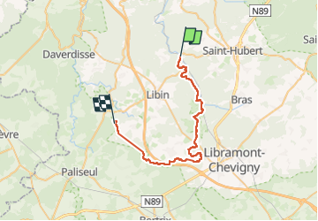
Poix Entre Lesse et Lomme

thomarche
Gebruiker

Lengte
35 km

Max. hoogte
498 m

Positief hoogteverschil
786 m
Km-Effort
45 km

Min. hoogte
319 m

Negatief hoogteverschil
740 m
Boucle
Neen
Datum van aanmaak :
2025-07-19 07:24:58.0
Laatste wijziging :
2025-07-20 06:43:31.899
20h43
Moeilijkheid : Gemakkelijk

Gratisgps-wandelapplicatie
 SityTrail
IGN / Geografische instituten
SityTrail Plus
De wereld gaat voor u open
Over ons
Tocht Stappen van 35 km beschikbaar op Wallonië, Luxemburg, Saint-Hubert. Deze tocht wordt voorgesteld door thomarche.
Beschrijving
Belle 1ere partie de boucle
Plaatsbepaling
Land:
Belgium
Regio :
Wallonië
Departement/Provincie :
Luxemburg
Gemeente :
Saint-Hubert
Locatie:
Unknown
Vertrek:(Dec)
Vertrek:(UTM)
664243 ; 5543367 (31U) N.
Opmerkingen