


2025 08 08 le canal de la suie

OLYMP42
Gebruiker
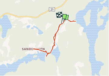

Lengte
4,6 km

Max. hoogte
216 m

Positief hoogteverschil
55 m
Km-Effort
5,4 km

Min. hoogte
185 m

Negatief hoogteverschil
55 m
Boucle
Ja
Datum van aanmaak :
2025-08-08 10:28:40.361
Laatste wijziging :
2025-08-08 13:09:38.191
2h40
Moeilijkheid : Gemakkelijk

Gratisgps-wandelapplicatie
 SityTrail
IGN / Geografische instituten
SityTrail Plus
De wereld gaat voor u open
Over ons
Tocht Stappen van 4,6 km beschikbaar op Innlandet. Deze tocht wordt voorgesteld door OLYMP42.
Plaatsbepaling
Land:
Norway
Regio :
Innlandet
Departement/Provincie :
Unknown
Gemeente :
Unknown
Locatie:
Unknown
Vertrek:(Dec)
Vertrek:(UTM)
660029 ; 6642963 (32V) N.
Opmerkingen