


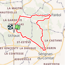
massif d uchaux

losjo
Gebruiker

Lengte
17 km

Max. hoogte
266 m

Positief hoogteverschil
371 m
Km-Effort
22 km

Min. hoogte
89 m

Negatief hoogteverschil
371 m
Boucle
Ja
Datum van aanmaak :
2018-03-06 00:00:00.0
Laatste wijziging :
2018-03-06 00:00:00.0
4h41
Moeilijkheid : Medium

Gratisgps-wandelapplicatie
 SityTrail
IGN / Geografische instituten
SityTrail Plus
De wereld gaat voor u open
Over ons
Tocht Stappen van 17 km beschikbaar op Provence-Alpes-Côte d'Azur, Vaucluse, Uchaux. Deze tocht wordt voorgesteld door losjo.
Plaatsbepaling
Land:
France
Regio :
Provence-Alpes-Côte d'Azur
Departement/Provincie :
Vaucluse
Gemeente :
Uchaux
Locatie:
Unknown
Vertrek:(Dec)
Vertrek:(UTM)
643953 ; 4896963 (31T) N.
Opmerkingen