


circuit par Château Paulignan

jsaun
Gebruiker
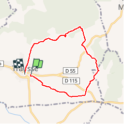

Lengte
6,9 km

Max. hoogte
175 m

Positief hoogteverschil
77 m
Km-Effort
7,9 km

Min. hoogte
129 m

Negatief hoogteverschil
72 m
Boucle
Ja
Datum van aanmaak :
2015-11-01 00:00:00.0
Laatste wijziging :
2015-11-01 00:00:00.0
1h50
Moeilijkheid : Gemakkelijk

Gratisgps-wandelapplicatie
 SityTrail
IGN / Geografische instituten
SityTrail Plus
De wereld gaat voor u open
Over ons
Tocht Stappen van 6,9 km beschikbaar op Occitanië, Aude, Trausse. Deze tocht wordt voorgesteld door jsaun.
Beschrijving
entre les vignes et la garrigue
Plaatsbepaling
Land:
France
Regio :
Occitanië
Departement/Provincie :
Aude
Gemeente :
Trausse
Locatie:
Unknown
Vertrek:(Dec)
Vertrek:(UTM)
464674 ; 4795484 (31T) N.
Opmerkingen