Tocht Andere activiteiten Larchant - PREPA M&R 170303 (ex.GLM160204) DJouanne - Photo

PREPA M&R 170303 (ex.GLM160204) DJouanne

 randodan
randodan

Gebruiker

© OpenStreetMap contributors
Lengte
Lengte
12,4 km
Max. hoogte
Max. hoogte
120 m
Positief hoogteverschil
246 m
Km-Effort
Km-Effort  
15,7 km
Min. hoogte
Min. hoogte
68 m
Negatief hoogteverschil
247 m
Boucle
Boucle
Ja
Datum van aanmaak :
2017-05-26 00:00:00.0
Laatste wijziging :
2017-05-26 00:00:00.0

(0 Bericht)

Andere activiteiten
Andere activiteiten
2h34
Moeilijkheid : Onbekend

Scan deze QR-code om de tocht te openen in de SityTrail-applicatie

Gratisgps-wandelapplicatie

Logo SityTrail SityTrail

IGN / Geografische instituten

SityTrail uit de App Store downloaden SityTrail uit Google Play downloaden

Logo SityTrail SityTrail Plus

De wereld gaat voor u open

SityTrail uit de App Store downloaden SityTrail uit Google Play downloaden SityTrail op Huawei AppGallery downloaden

Over ons

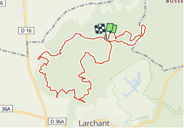
Tocht Andere activiteiten van 12,4 km beschikbaar op Île-de-France, Seine-et-Marne, Larchant. Deze tocht wordt voorgesteld door randodan.

Beschrijving

PREPA Déné19/DameJouanne GLM
pour le 160211
Copie modifiée de 121031 :
prepa Déné.19 avec Mi Lo
Position des POI Maunoury corrigée suite à la RECO.<br>
Recorrigé pour F.StBernard et horaires pour M&R 170303 (dép.: 9h30).

Hoogteprofiel

POI's

POI Larchant - simonet - Photo
randodan
LARCHANT 
POI Larchant - A - Photo
randodan
LARCHANT 
POI Larchant - B - Photo
randodan
LARCHANT 
POI Larchant - C - Photo
randodan
LARCHANT 
POI Larchant - D - Photo
randodan
LARCHANT 
POI Larchant - E - Photo
randodan
LARCHANT 
POI Larchant - crottes au fer - Photo
randodan
LARCHANT 
POI Larchant - Mont Blanc - Photo
randodan
LARCHANT 
POI Larchant - carrière - Photo
randodan
LARCHANT 
POI Larchant - à G - Photo
randodan
LARCHANT 
POI Larchant - à G - Photo
randodan
LARCHANT 
POI Larchant - à g - Photo
randodan
LARCHANT 
POI Larchant - à D - Photo
randodan
LARCHANT 
POI Larchant - à g - Photo
randodan
LARCHANT 
POI Larchant - nouveau tracé - Photo
randodan
LARCHANT 
POI Larchant - Fontaine StBernard - Photo
randodan
POI Larchant - justice - Photo
randodan
LARCHANT 
POI Larchant - StMathurin - Photo
randodan
LARCHANT 
POI Larchant - à G - Photo
randodan
LARCHANT 
POI Larchant - Roc.Lapin - Photo
randodan
LARCHANT 
POI Larchant - Roc.Pendule - Photo
randodan
LARCHANT 
POI Larchant - F - Photo
randodan
LARCHANT 
POI Larchant - DJ et G - Photo
randodan
LARCHANT 
POI Larchant - H - Photo
randodan
LARCHANT 
POI Larchant - I - Photo
randodan
LARCHANT 
POI Larchant - J - Photo
randodan
LARCHANT 
POI Larchant - K - Photo
randodan
LARCHANT 
POI Larchant - Maunoury - Photo
randodan
LARCHANT 
POI Larchant - L - Photo
randodan
LARCHANT 
POI Larchant - DJ - Photo
randodan
LARCHANT 
POI Villiers-sous-Grez - à d - Photo
randodan
VILLIERS-SOUS-GREZ 
POI Villiers-sous-Grez - à g - Photo
randodan
VILLIERS-SOUS-GREZ 
POI Villiers-sous-Grez - ttd - Photo
randodan
VILLIERS-SOUS-GREZ 
POI Villiers-sous-Grez - ttd - Photo
randodan
VILLIERS-SOUS-GREZ 
POI Larchant - sortie grillagée - Photo
randodan
POI Larchant - à G - Photo
randodan
LARCHANT 
POI Larchant - tt droit - Photo
randodan
LARCHANT 
POI Larchant - gravure poisson - Photo
randodan
LARCHANT 
POI Larchant - futur HP - Photo
randodan
LARCHANT 

Plaatsbepaling

Land:
France
Regio :
Île-de-France
Departement/Provincie :
Seine-et-Marne
Gemeente :
Larchant
Locatie:
Unknown
Vertrek:(Dec)
Vertrek:(UTM)
470311 ; 5350052 (31U) N.


Sluiten
Mijn abonnementen