


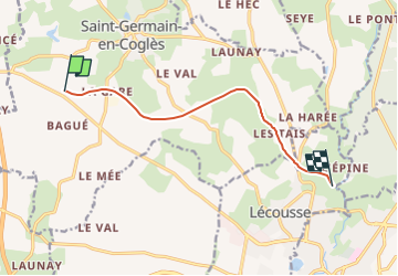
croix triquet pont aux anes voie verte a/r 15km

coglais
Gebruiker

Lengte
7,7 km

Max. hoogte
165 m

Positief hoogteverschil
56 m
Km-Effort
8,5 km

Min. hoogte
123 m

Negatief hoogteverschil
67 m
Boucle
Neen
Datum van aanmaak :
2016-01-21 00:00:00.0
Laatste wijziging :
2023-01-21 17:18:34.286
1h30
Moeilijkheid : Gemakkelijk

Gratisgps-wandelapplicatie
 SityTrail
IGN / Geografische instituten
SityTrail Plus
De wereld gaat voor u open
Over ons
Tocht Noords wandelen van 7,7 km beschikbaar op Bretagne, Ille-et-Vilaine, Saint-Germain-en-Coglès. Deze tocht wordt voorgesteld door coglais.
Plaatsbepaling
Land:
France
Regio :
Bretagne
Departement/Provincie :
Ille-et-Vilaine
Gemeente :
Saint-Germain-en-Coglès
Locatie:
Unknown
Vertrek:(Dec)
Vertrek:(UTM)
626975 ; 5361445 (30U) N.
Opmerkingen