


Levast0316

rollondesbois
Gebruiker
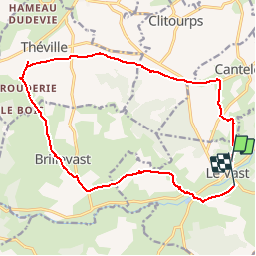

Lengte
16,2 km

Max. hoogte
129 m

Positief hoogteverschil
209 m
Km-Effort
19 km

Min. hoogte
27 m

Negatief hoogteverschil
223 m
Boucle
Neen
Datum van aanmaak :
2016-03-09 00:00:00.0
Laatste wijziging :
2016-03-09 00:00:00.0
4h00
Moeilijkheid : Onbekend

Gratisgps-wandelapplicatie
 SityTrail
IGN / Geografische instituten
SityTrail Plus
De wereld gaat voor u open
Over ons
Tocht Andere activiteiten van 16,2 km beschikbaar op Normandië, Manche, Le Vast. Deze tocht wordt voorgesteld door rollondesbois.
Plaatsbepaling
Land:
France
Regio :
Normandië
Departement/Provincie :
Manche
Gemeente :
Le Vast
Locatie:
Unknown
Vertrek:(Dec)
Vertrek:(UTM)
618651 ; 5498121 (30U) N.
Opmerkingen