


Rando santé 2 - Courcelles les Gisors

marcel.F
Gebruiker
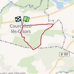

Lengte
4,3 km

Max. hoogte
133 m

Positief hoogteverschil
65 m
Km-Effort
5,1 km

Min. hoogte
68 m

Negatief hoogteverschil
65 m
Boucle
Ja
Datum van aanmaak :
2019-04-01 20:24:04.371
Laatste wijziging :
2019-04-05 20:28:06.807
1h30
Moeilijkheid : Gemakkelijk

Gratisgps-wandelapplicatie
 SityTrail
IGN / Geografische instituten
SityTrail Plus
De wereld gaat voor u open
Over ons
Tocht Stappen van 4,3 km beschikbaar op Hauts-de-France, Oise, Courcelles-lès-Gisors. Deze tocht wordt voorgesteld door marcel.F.
Beschrijving
Parcours départ parking salle des fêtes de Courcelles les Gisors (60)
Plaatsbepaling
Land:
France
Regio :
Hauts-de-France
Departement/Provincie :
Oise
Gemeente :
Courcelles-lès-Gisors
Locatie:
Unknown
Vertrek:(Dec)
Vertrek:(UTM)
408569 ; 5457233 (31U) N.
Opmerkingen