


rots 10 kms 2016

aubinjoel
Gebruiker
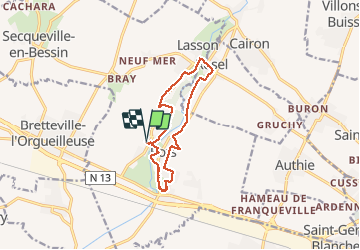

Lengte
10,4 km

Max. hoogte
63 m

Positief hoogteverschil
80 m
Km-Effort
11,4 km

Min. hoogte
38 m

Negatief hoogteverschil
80 m
Boucle
Ja
Datum van aanmaak :
2016-03-09 00:00:00.0
Laatste wijziging :
2016-03-09 00:00:00.0
1h46
Moeilijkheid : Gemakkelijk

Gratisgps-wandelapplicatie
 SityTrail
IGN / Geografische instituten
SityTrail Plus
De wereld gaat voor u open
Over ons
Tocht Noords wandelen van 10,4 km beschikbaar op Normandië, Calvados, Rots. Deze tocht wordt voorgesteld door aubinjoel.
Beschrijving
Toussote 10 km dépôts 10 kms
Plaatsbepaling
Land:
France
Regio :
Normandië
Departement/Provincie :
Calvados
Gemeente :
Rots
Locatie:
Rots
Vertrek:(Dec)
Vertrek:(UTM)
683396 ; 5454068 (30U) N.
Opmerkingen