


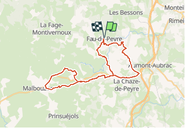
sortie week-end Vtt en Lozère dimanche 10-04-2016

Chiroptere
Gebruiker

Lengte
35 km

Max. hoogte
1181 m

Positief hoogteverschil
678 m
Km-Effort
44 km

Min. hoogte
1029 m

Negatief hoogteverschil
678 m
Boucle
Ja
Datum van aanmaak :
2016-04-11 00:00:00.0
Laatste wijziging :
2016-04-11 00:00:00.0
2h52
Moeilijkheid : Moeilijk

Gratisgps-wandelapplicatie
 SityTrail
IGN / Geografische instituten
SityTrail Plus
De wereld gaat voor u open
Over ons
Tocht Mountainbike van 35 km beschikbaar op Occitanië, Lozère, Peyre en Aubrac. Deze tocht wordt voorgesteld door Chiroptere.
Plaatsbepaling
Land:
France
Regio :
Occitanië
Departement/Provincie :
Lozère
Gemeente :
Peyre en Aubrac
Locatie:
Unknown
Vertrek:(Dec)
Vertrek:(UTM)
517657 ; 4955056 (31T) N.
Opmerkingen