


Val de creuë

kikkko
Gebruiker
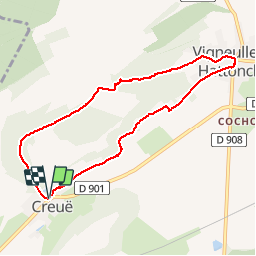

Lengte
7,6 km

Max. hoogte
376 m

Positief hoogteverschil
157 m
Km-Effort
9,7 km

Min. hoogte
256 m

Negatief hoogteverschil
158 m
Boucle
Ja
Datum van aanmaak :
2016-04-27 00:00:00.0
Laatste wijziging :
2016-04-27 00:00:00.0
2h05
Moeilijkheid : Gemakkelijk

Gratisgps-wandelapplicatie
 SityTrail
IGN / Geografische instituten
SityTrail Plus
De wereld gaat voor u open
Over ons
Tocht Stappen van 7,6 km beschikbaar op Grand Est, Meuse, Vigneulles-lès-Hattonchâtel. Deze tocht wordt voorgesteld door kikkko.
Beschrijving
jolie randonnée dans les vergers puis en forêt balisée rond jaune
Plaatsbepaling
Land:
France
Regio :
Grand Est
Departement/Provincie :
Meuse
Gemeente :
Vigneulles-lès-Hattonchâtel
Locatie:
Unknown
Vertrek:(Dec)
Vertrek:(UTM)
695449 ; 5427040 (31U) N.
Opmerkingen