


tandounet laburgade 2

cps46
Gebruiker
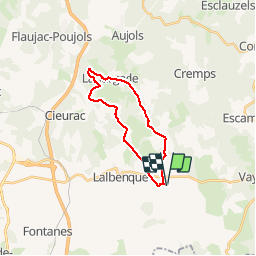

Lengte
19,9 km

Max. hoogte
288 m

Positief hoogteverschil
285 m
Km-Effort
24 km

Min. hoogte
204 m

Negatief hoogteverschil
285 m
Boucle
Ja
Datum van aanmaak :
2016-04-28 00:00:00.0
Laatste wijziging :
2016-04-28 00:00:00.0
1h39
Moeilijkheid : Onbekend

Gratisgps-wandelapplicatie
 SityTrail
IGN / Geografische instituten
SityTrail Plus
De wereld gaat voor u open
Over ons
Tocht Mountainbike van 19,9 km beschikbaar op Occitanië, Lot, Lalbenque. Deze tocht wordt voorgesteld door cps46.
Plaatsbepaling
Land:
France
Regio :
Occitanië
Departement/Provincie :
Lot
Gemeente :
Lalbenque
Locatie:
Unknown
Vertrek:(Dec)
Vertrek:(UTM)
386709 ; 4909876 (31T) N.
Opmerkingen