


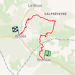
RISTOLAS - ABRIES

bourel.jacques
Gebruiker

Lengte
12,2 km

Max. hoogte
2371 m

Positief hoogteverschil
802 m
Km-Effort
23 km

Min. hoogte
1552 m

Negatief hoogteverschil
863 m
Boucle
Neen
Datum van aanmaak :
2016-05-26 00:00:00.0
Laatste wijziging :
2016-05-26 00:00:00.0
4h49
Moeilijkheid : Moeilijk

Gratisgps-wandelapplicatie
 SityTrail
IGN / Geografische instituten
SityTrail Plus
De wereld gaat voor u open
Over ons
Tocht Stappen van 12,2 km beschikbaar op Provence-Alpes-Côte d'Azur, Hautes-Alpes, Abriès-Ristolas. Deze tocht wordt voorgesteld door bourel.jacques.
Beschrijving
Tour du Queyras - Etape 4
Plaatsbepaling
Land:
France
Regio :
Provence-Alpes-Côte d'Azur
Departement/Provincie :
Hautes-Alpes
Gemeente :
Abriès-Ristolas
Locatie:
Unknown
Vertrek:(Dec)
Vertrek:(UTM)
338226 ; 4959882 (32T) N.
Opmerkingen