


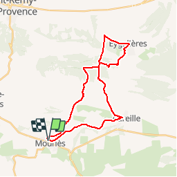
Mouriès-Eygalières

leeho
Gebruiker

Lengte
30 km

Max. hoogte
252 m

Positief hoogteverschil
489 m
Km-Effort
37 km

Min. hoogte
16 m

Negatief hoogteverschil
490 m
Boucle
Ja
Datum van aanmaak :
2016-07-05 00:00:00.0
Laatste wijziging :
2016-07-05 00:00:00.0
2h07
Moeilijkheid : Medium

Gratisgps-wandelapplicatie
 SityTrail
IGN / Geografische instituten
SityTrail Plus
De wereld gaat voor u open
Over ons
Tocht Fiets van 30 km beschikbaar op Provence-Alpes-Côte d'Azur, Bouches-du-Rhône. Deze tocht wordt voorgesteld door leeho.
Beschrijving
Boucle Mouriès-Eygalières en VTC


Plaatsbepaling
Land:
France
Regio :
Provence-Alpes-Côte d'Azur
Departement/Provincie :
Bouches-du-Rhône
Gemeente :
MOURIES
Locatie:
Unknown
Vertrek:(Dec)
Vertrek:(UTM)
650712 ; 4839318 (31T) N.
Opmerkingen