


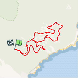
Boucle autour du Pic du Cap Roux - 22 juil 2016

morganee
Gebruiker

Lengte
10,7 km

Max. hoogte
440 m

Positief hoogteverschil
475 m
Km-Effort
17 km

Min. hoogte
129 m

Negatief hoogteverschil
475 m
Boucle
Ja
Datum van aanmaak :
2019-07-19 19:06:02.346
Laatste wijziging :
2019-07-19 19:06:02.465
3h33
Moeilijkheid : Gemakkelijk

Gratisgps-wandelapplicatie
 SityTrail
IGN / Geografische instituten
SityTrail Plus
De wereld gaat voor u open
Over ons
Tocht Stappen van 10,7 km beschikbaar op Provence-Alpes-Côte d'Azur, Var, Saint-Raphaël. Deze tocht wordt voorgesteld door morganee.
Plaatsbepaling
Land:
France
Regio :
Provence-Alpes-Côte d'Azur
Departement/Provincie :
Var
Gemeente :
Saint-Raphaël
Locatie:
Unknown
Vertrek:(Dec)
Vertrek:(UTM)
328826 ; 4812726 (32T) N.
Opmerkingen