


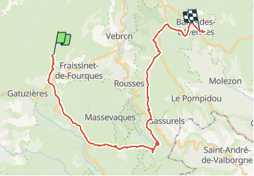
L'Hom-Barres des Cévennes

alfreson
Gebruiker

Lengte
35 km

Max. hoogte
1268 m

Positief hoogteverschil
851 m
Km-Effort
47 km

Min. hoogte
891 m

Negatief hoogteverschil
981 m
Boucle
Neen
Datum van aanmaak :
2016-08-10 00:00:00.0
Laatste wijziging :
2016-08-10 00:00:00.0
20h35
Moeilijkheid : Gemakkelijk

Gratisgps-wandelapplicatie
 SityTrail
IGN / Geografische instituten
SityTrail Plus
De wereld gaat voor u open
Over ons
Tocht Paard van 35 km beschikbaar op Occitanië, Lozère, Fraissinet-de-Fourques. Deze tocht wordt voorgesteld door alfreson.
Beschrijving
On quitte les Causses pour les forêts vers les cols et le Mont Aiguoual
Foto's


57 fotos in totaal. Klik op een foto om ze allemaal in de galerij weer te geven.


Plaatsbepaling
Land:
France
Regio :
Occitanië
Departement/Provincie :
Lozère
Gemeente :
Fraissinet-de-Fourques
Locatie:
Unknown
Vertrek:(Dec)
Vertrek:(UTM)
541107 ; 4897145 (31T) N.
Opmerkingen