


sallenelles

thle
Gebruiker
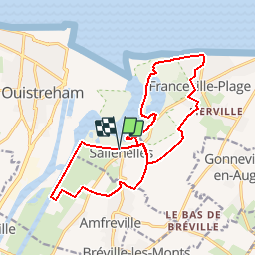

Lengte
16,2 km

Max. hoogte
49 m

Positief hoogteverschil
117 m
Km-Effort
17,8 km

Min. hoogte
-1 m

Negatief hoogteverschil
120 m
Boucle
Ja
Datum van aanmaak :
2016-09-01 00:00:00.0
Laatste wijziging :
2016-09-01 00:00:00.0
2h13
Moeilijkheid : Gemakkelijk

Gratisgps-wandelapplicatie
 SityTrail
IGN / Geografische instituten
SityTrail Plus
De wereld gaat voor u open
Over ons
Tocht Paard van 16,2 km beschikbaar op Normandië, Calvados, Sallenelles. Deze tocht wordt voorgesteld door thle.
Plaatsbepaling
Land:
France
Regio :
Normandië
Departement/Provincie :
Calvados
Gemeente :
Sallenelles
Locatie:
Unknown
Vertrek:(Dec)
Vertrek:(UTM)
701426 ; 5460546 (30U) N.
Opmerkingen