


olhain MN 2016

dehemjacques
Gebruiker
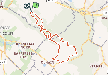

Lengte
8,1 km

Max. hoogte
196 m

Positief hoogteverschil
217 m
Km-Effort
11 km

Min. hoogte
89 m

Negatief hoogteverschil
222 m
Boucle
Ja
Datum van aanmaak :
2016-09-20 00:00:00.0
Laatste wijziging :
2016-09-20 00:00:00.0
1h50
Moeilijkheid : Medium

Gratisgps-wandelapplicatie
 SityTrail
IGN / Geografische instituten
SityTrail Plus
De wereld gaat voor u open
Over ons
Tocht Noords wandelen van 8,1 km beschikbaar op Hauts-de-France, Pas-de-Calais, Maisnil-lès-Ruitz. Deze tocht wordt voorgesteld door dehemjacques.
Plaatsbepaling
Land:
France
Regio :
Hauts-de-France
Departement/Provincie :
Pas-de-Calais
Gemeente :
Maisnil-lès-Ruitz
Locatie:
Unknown
Vertrek:(Dec)
Vertrek:(UTM)
469880 ; 5588048 (31U) N.
Opmerkingen