


Forges A9

Blixsup
Gebruiker

Lengte
21 km

Max. hoogte
189 m

Positief hoogteverschil
256 m
Km-Effort
24 km

Min. hoogte
118 m

Negatief hoogteverschil
259 m
Boucle
Ja
Datum van aanmaak :
2016-12-21 00:00:00.0
Laatste wijziging :
2016-12-21 00:00:00.0
5h14
Moeilijkheid : Medium

Gratisgps-wandelapplicatie
 SityTrail
IGN / Geografische instituten
SityTrail Plus
De wereld gaat voor u open
Over ons
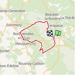
Tocht Stappen van 21 km beschikbaar op Normandië, Seine-Maritime, Forges-les-Eaux. Deze tocht wordt voorgesteld door Blixsup.
Beschrijving
RONCHEROLLES-EN-BRAY
FORGES-LES-EAUX
Plaatsbepaling
Land:
France
Regio :
Normandië
Departement/Provincie :
Seine-Maritime
Gemeente :
Forges-les-Eaux
Locatie:
Forges-les-Eaux
Vertrek:(Dec)
Vertrek:(UTM)
394152 ; 5496245 (31U) N.
Opmerkingen