


Basse Normandie - Ligne 00F - Alençon - Domfront Partie 2

mich54
Gebruiker

Lengte
3,1 km

Max. hoogte
150 m

Positief hoogteverschil
15 m
Km-Effort
3,3 km

Min. hoogte
123 m

Negatief hoogteverschil
26 m
Boucle
Neen
Datum van aanmaak :
2017-01-18 00:00:00.0
Laatste wijziging :
2017-01-18 00:00:00.0
5m
Moeilijkheid : Onbekend

Gratisgps-wandelapplicatie
 SityTrail
IGN / Geografische instituten
SityTrail Plus
De wereld gaat voor u open
Over ons
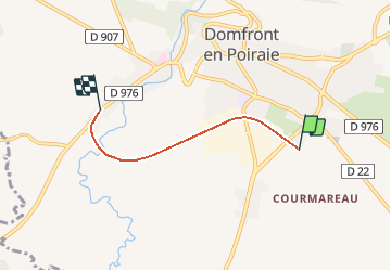
Tocht Andere activiteiten van 3,1 km beschikbaar op Normandië, Orne, Domfront en Poiraie. Deze tocht wordt voorgesteld door mich54.
Beschrijving
Partie 2 de Saint-Front à Domfront (la section entre Saint-Front et Beaulandais est trop incertaine pour être tracée).
Plaatsbepaling
Land:
France
Regio :
Normandië
Departement/Provincie :
Orne
Gemeente :
Domfront en Poiraie
Locatie:
Domfront
Vertrek:(Dec)
Vertrek:(UTM)
674287 ; 5383640 (30U) N.
Opmerkingen