


Asnières 27 le22012017

Laurent53
Gebruiker
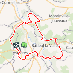

Lengte
19,3 km

Max. hoogte
163 m

Positief hoogteverschil
266 m
Km-Effort
23 km

Min. hoogte
84 m

Negatief hoogteverschil
265 m
Boucle
Ja
Datum van aanmaak :
2017-01-26 00:00:00.0
Laatste wijziging :
2017-01-26 00:00:00.0
5h28
Moeilijkheid : Gemakkelijk

Gratisgps-wandelapplicatie
 SityTrail
IGN / Geografische instituten
SityTrail Plus
De wereld gaat voor u open
Over ons
Tocht Stappen van 19,3 km beschikbaar op Normandië, Eure, Asnières. Deze tocht wordt voorgesteld door Laurent53.


Plaatsbepaling
Land:
France
Regio :
Normandië
Departement/Provincie :
Eure
Gemeente :
Asnières
Locatie:
Unknown
Vertrek:(Dec)
Vertrek:(UTM)
310398 ; 5452537 (31U) N.
Opmerkingen