Tocht Stappen Plainfaing - chemin du page - Photo
 papiou
papiou

Gebruiker

© OpenStreetMap contributors
Lengte
Lengte
9,7 km
Max. hoogte
Max. hoogte
979 m
Positief hoogteverschil
357 m
Km-Effort
Km-Effort  
14,4 km
Min. hoogte
Min. hoogte
637 m
Negatief hoogteverschil
354 m
Boucle
Boucle
Ja
Datum van aanmaak :
2017-02-02 00:00:00.0
Laatste wijziging :
2017-02-02 00:00:00.0

(0 Bericht)

Stappen
Stappen
2h24
Moeilijkheid : Medium

Scan deze QR-code om de tocht te openen in de SityTrail-applicatie

Gratisgps-wandelapplicatie

Logo SityTrail SityTrail

IGN / Geografische instituten

SityTrail uit de App Store downloaden SityTrail uit Google Play downloaden

Logo SityTrail SityTrail Plus

De wereld gaat voor u open

SityTrail uit de App Store downloaden SityTrail uit Google Play downloaden SityTrail op Huawei AppGallery downloaden

Over ons

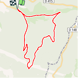
Tocht Stappen van 9,7 km beschikbaar op Grand Est, Vogezen, Plainfaing. Deze tocht wordt voorgesteld door papiou.

Beschrijving

Rdv Baracon ,se garer près centrale. partir vers la montagne puis prendre légèrement sur la droite vers chaume. à la fin du Macadam et à côté d'un petit pont prendre à gauche et entrer dans forêt des hospices qui monte en lacets, passer 2 fois sous lignes EDF puis dans un virage aller tout droit par le chemin du page qui rejoint l'ancienne route du col qu'il faut redescendre jusqu'au point de départ.

Hoogteprofiel

Plaatsbepaling

Land:
France
Regio :
Grand Est
Departement/Provincie :
Vogezen
Gemeente :
Plainfaing
Locatie:
Unknown
Vertrek:(Dec)
Vertrek:(UTM)
354431 ; 5336531 (32U) N.


Sluiten
Mijn abonnementen