


Les cascades queue de cheval et queue de l'âne

micheldutilleul
Gebruiker
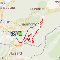

Lengte
7,6 km

Max. hoogte
695 m

Positief hoogteverschil
326 m
Km-Effort
12 km

Min. hoogte
463 m

Negatief hoogteverschil
326 m
Boucle
Ja
Datum van aanmaak :
2017-04-02 00:00:00.0
Laatste wijziging :
2017-04-02 00:00:00.0
2h12
Moeilijkheid : Moeilijk

Gratisgps-wandelapplicatie
 SityTrail
IGN / Geografische instituten
SityTrail Plus
De wereld gaat voor u open
Over ons
Tocht Stappen van 7,6 km beschikbaar op Bourgondië-Franche-Comté, Jura, Saint-Claude. Deze tocht wordt voorgesteld door micheldutilleul.
Foto's

Plaatsbepaling
Land:
France
Regio :
Bourgondië-Franche-Comté
Departement/Provincie :
Jura
Gemeente :
Saint-Claude
Locatie:
Unknown
Vertrek:(Dec)
Vertrek:(UTM)
721141 ; 5140187 (31T) N.
Opmerkingen