Tocht Stappen Profondeville - Lustin Bob G...9-4-2017 - Photo

Lustin Bob G...9-4-2017

 r.genette
r.genette

Gebruiker

© OpenStreetMap contributors
Lengte
Lengte
10,2 km
Max. hoogte
Max. hoogte
277 m
Positief hoogteverschil
205 m
Km-Effort
Km-Effort  
12,9 km
Min. hoogte
Min. hoogte
183 m
Negatief hoogteverschil
205 m
Boucle
Boucle
Ja
Datum van aanmaak :
2017-07-08 00:00:00.0
Laatste wijziging :
2017-07-08 00:00:00.0

(0 Bericht)

Stappen
Stappen
2h20
Moeilijkheid : Medium

Scan deze QR-code om de tocht te openen in de SityTrail-applicatie

Gratisgps-wandelapplicatie

Logo SityTrail SityTrail

IGN / Geografische instituten

SityTrail uit de App Store downloaden SityTrail uit Google Play downloaden

Logo SityTrail SityTrail Plus

De wereld gaat voor u open

SityTrail uit de App Store downloaden SityTrail uit Google Play downloaden SityTrail op Huawei AppGallery downloaden

Over ons

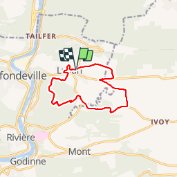
Tocht Stappen van 10,2 km beschikbaar op Wallonië, Namen, Profondeville. Deze tocht wordt voorgesteld door r.genette.

Beschrijving

Découverte du village par des petits chemins, très beaux sentiers dans le bois de Nimes, passage près de la ferme du trou d'Haquin, bois de Biamont, tri d'Ivoy, ferme de Marconvaux, Les Dossias et retour par Chap. St-Donat..(Sonia Baily resp de la marche)

Hoogteprofiel

Plaatsbepaling

Land:
Belgium
Regio :
Wallonië
Departement/Provincie :
Namen
Gemeente :
Profondeville
Locatie:
Lustin
Vertrek:(Dec)
Vertrek:(UTM)
635107 ; 5582519 (31U) N.


Sluiten
Mijn abonnementen