


Hamoir - Promenade de Xhenceval

colsonandre
Gebruiker
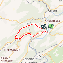

Lengte
8,8 km

Max. hoogte
278 m

Positief hoogteverschil
213 m
Km-Effort
11,6 km

Min. hoogte
114 m

Negatief hoogteverschil
211 m
Boucle
Ja
Datum van aanmaak :
2014-12-10 00:00:00.0
Laatste wijziging :
2019-08-10 17:12:43.079
2h31
Moeilijkheid : Gemakkelijk

Gratisgps-wandelapplicatie
 SityTrail
IGN / Geografische instituten
SityTrail Plus
De wereld gaat voor u open
Over ons
Tocht Stappen van 8,8 km beschikbaar op Wallonië, Luik, Hamoir. Deze tocht wordt voorgesteld door colsonandre.
Beschrijving
très belle et difficile
Plaatsbepaling
Land:
Belgium
Regio :
Wallonië
Departement/Provincie :
Luik
Gemeente :
Hamoir
Locatie:
Hamoir
Vertrek:(Dec)
Vertrek:(UTM)
680141 ; 5589130 (31U) N.
Opmerkingen
très belle et départ difficile.