


trois-ponts-33

PhilippeC54
Gebruiker
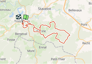

Lengte
33 km

Max. hoogte
592 m

Positief hoogteverschil
728 m
Km-Effort
43 km

Min. hoogte
250 m

Negatief hoogteverschil
736 m
Boucle
Ja
Datum van aanmaak :
2017-04-26 00:00:00.0
Laatste wijziging :
2017-04-26 00:00:00.0
2h46
Moeilijkheid : Onbekend

Gratisgps-wandelapplicatie
 SityTrail
IGN / Geografische instituten
SityTrail Plus
De wereld gaat voor u open
Over ons
Tocht Mountainbike van 33 km beschikbaar op Wallonië, Luik, Trois-Ponts. Deze tocht wordt voorgesteld door PhilippeC54.
Plaatsbepaling
Land:
Belgium
Regio :
Wallonië
Departement/Provincie :
Luik
Gemeente :
Trois-Ponts
Locatie:
Fosse
Vertrek:(Dec)
Vertrek:(UTM)
704211 ; 5583670 (31U) N.
Opmerkingen