ryes 8 kms 2017

aubinjoel
Gebruiker
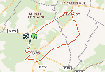

Lengte
7,8 km

Max. hoogte
57 m

Positief hoogteverschil
66 m
Km-Effort
8,7 km

Min. hoogte
11 m

Negatief hoogteverschil
70 m
Boucle
Ja
Datum van aanmaak :
2017-07-10 00:00:00.0
Laatste wijziging :
2017-07-10 00:00:00.0
--
Moeilijkheid : Gemakkelijk

Gratisgps-wandelapplicatie
 SityTrail
IGN / Geografische instituten
SityTrail Plus
De wereld gaat voor u open
Over ons
Tocht Stappen van 7,8 km beschikbaar op Normandië, Calvados, Ryes. Deze tocht wordt voorgesteld door aubinjoel.


Plaatsbepaling
Land:
France
Regio :
Normandië
Departement/Provincie :
Calvados
Gemeente :
Ryes
Locatie:
Unknown
Vertrek:(Dec)
Vertrek:(UTM)
672335 ; 5465256 (30U) N.
Opmerkingen