


hattonvers etanche

ochelen
Gebruiker
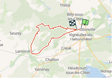

Lengte
24 km

Max. hoogte
412 m

Positief hoogteverschil
393 m
Km-Effort
29 km

Min. hoogte
241 m

Negatief hoogteverschil
390 m
Boucle
Neen
Datum van aanmaak :
2017-07-15 00:00:00.0
Laatste wijziging :
2017-07-15 00:00:00.0
3h39
Moeilijkheid : Onbekend

Gratisgps-wandelapplicatie
 SityTrail
IGN / Geografische instituten
SityTrail Plus
De wereld gaat voor u open
Over ons
Tocht Paard van 24 km beschikbaar op Grand Est, Meuse, Vigneulles-lès-Hattonchâtel. Deze tocht wordt voorgesteld door ochelen.
Plaatsbepaling
Land:
France
Regio :
Grand Est
Departement/Provincie :
Meuse
Gemeente :
Vigneulles-lès-Hattonchâtel
Locatie:
Hattonchâtel
Vertrek:(Dec)
Vertrek:(UTM)
697743 ; 5430093 (31U) N.
Opmerkingen