


Le Val de Cusance

micheldutilleul
Gebruiker

Lengte
12,7 km

Max. hoogte
493 m

Positief hoogteverschil
403 m
Km-Effort
18,1 km

Min. hoogte
302 m

Negatief hoogteverschil
402 m
Boucle
Ja
Datum van aanmaak :
2017-07-17 00:00:00.0
Laatste wijziging :
2017-07-17 00:00:00.0
4h00
Moeilijkheid : Medium

Gratisgps-wandelapplicatie
 SityTrail
IGN / Geografische instituten
SityTrail Plus
De wereld gaat voor u open
Over ons
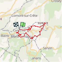
Tocht Stappen van 12,7 km beschikbaar op Bourgondië-Franche-Comté, Doubs, Cusance. Deze tocht wordt voorgesteld door micheldutilleul.
Beschrijving
Départ à l'église de Cusance
Plaatsbepaling
Land:
France
Regio :
Bourgondië-Franche-Comté
Departement/Provincie :
Doubs
Gemeente :
Cusance
Locatie:
Unknown
Vertrek:(Dec)
Vertrek:(UTM)
305425 ; 5244404 (32T) N.
Opmerkingen