


les sables

PhilippeC54
Gebruiker

Lengte
51 km

Max. hoogte
30 m

Positief hoogteverschil
309 m
Km-Effort
55 km

Min. hoogte
-2 m

Negatief hoogteverschil
309 m
Boucle
Ja
Datum van aanmaak :
2017-09-06 00:00:00.0
Laatste wijziging :
2017-09-06 00:00:00.0
6h28
Moeilijkheid : Heel gemakkelijk

Gratisgps-wandelapplicatie
 SityTrail
IGN / Geografische instituten
SityTrail Plus
De wereld gaat voor u open
Over ons
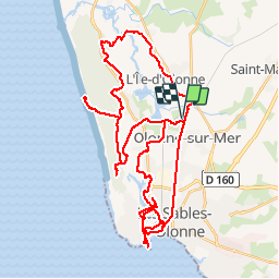
Tocht Fiets van 51 km beschikbaar op Pays de la Loire, Vendée, Les Sables-d'Olonne. Deze tocht wordt voorgesteld door PhilippeC54.
Plaatsbepaling
Land:
France
Regio :
Pays de la Loire
Departement/Provincie :
Vendée
Gemeente :
Les Sables-d'Olonne
Locatie:
Olonne-sur-Mer
Vertrek:(Dec)
Vertrek:(UTM)
594171 ; 5155181 (30T) N.
Opmerkingen