


COUTANCES CERENCES

UDGI54
Gebruiker
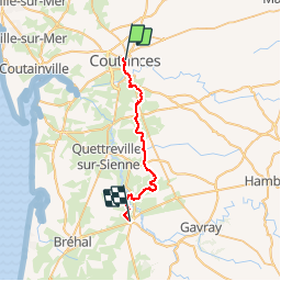

Lengte
23 km

Max. hoogte
97 m

Positief hoogteverschil
410 m
Km-Effort
29 km

Min. hoogte
15 m

Negatief hoogteverschil
446 m
Boucle
Neen
Datum van aanmaak :
2018-04-17 00:06:38.867
Laatste wijziging :
2018-04-17 00:06:38.867
--
Moeilijkheid : Onbekend

Gratisgps-wandelapplicatie
 SityTrail
IGN / Geografische instituten
SityTrail Plus
De wereld gaat voor u open
Over ons
Tocht Stappen van 23 km beschikbaar op Normandië, Manche, Coutances. Deze tocht wordt voorgesteld door UDGI54.
Plaatsbepaling
Land:
France
Regio :
Normandië
Departement/Provincie :
Manche
Gemeente :
Coutances
Locatie:
Unknown
Vertrek:(Dec)
Vertrek:(UTM)
613636 ; 5433917 (30U) N.
Opmerkingen