


les avins

colsonandre
Gebruiker
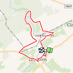

Lengte
7,6 km

Max. hoogte
259 m

Positief hoogteverschil
137 m
Km-Effort
9,4 km

Min. hoogte
199 m

Negatief hoogteverschil
137 m
Boucle
Ja
Datum van aanmaak :
2017-10-09 00:00:00.0
Laatste wijziging :
2019-08-10 18:20:12.823
2h28
Moeilijkheid : Onbekend

Gratisgps-wandelapplicatie
 SityTrail
IGN / Geografische instituten
SityTrail Plus
De wereld gaat voor u open
Over ons
Tocht Stappen van 7,6 km beschikbaar op Wallonië, Luik, Clavier. Deze tocht wordt voorgesteld door colsonandre.
Plaatsbepaling
Land:
Belgium
Regio :
Wallonië
Departement/Provincie :
Luik
Gemeente :
Clavier
Locatie:
Les Avins
Vertrek:(Dec)
Vertrek:(UTM)
663700 ; 5587468 (31U) N.
Opmerkingen