


p11 v2

PhilippeC54
Gebruiker
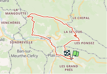

Lengte
17,3 km

Max. hoogte
795 m

Positief hoogteverschil
470 m
Km-Effort
24 km

Min. hoogte
482 m

Negatief hoogteverschil
470 m
Boucle
Ja
Datum van aanmaak :
2018-04-17 11:24:11.943
Laatste wijziging :
2018-04-17 11:24:11.943
2h17
Moeilijkheid : Onbekend

Gratisgps-wandelapplicatie
 SityTrail
IGN / Geografische instituten
SityTrail Plus
De wereld gaat voor u open
Over ons
Tocht Mountainbike van 17,3 km beschikbaar op Grand Est, Vogezen, Plainfaing. Deze tocht wordt voorgesteld door PhilippeC54.
Plaatsbepaling
Land:
France
Regio :
Grand Est
Departement/Provincie :
Vogezen
Gemeente :
Plainfaing
Locatie:
Unknown
Vertrek:(Dec)
Vertrek:(UTM)
353704 ; 5336963 (32U) N.
Opmerkingen