


Hiv2018-20-V2B

PhilippeC54
Gebruiker
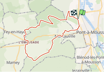

Lengte
18,3 km

Max. hoogte
373 m

Positief hoogteverschil
345 m
Km-Effort
23 km

Min. hoogte
175 m

Negatief hoogteverschil
345 m
Boucle
Ja
Datum van aanmaak :
2018-04-17 12:50:37.235
Laatste wijziging :
2018-04-17 12:50:37.235
1h31
Moeilijkheid : Gemakkelijk

Gratisgps-wandelapplicatie
 SityTrail
IGN / Geografische instituten
SityTrail Plus
De wereld gaat voor u open
Over ons
Tocht Mountainbike van 18,3 km beschikbaar op Grand Est, Meurthe-et-Moselle, Pont-à-Mousson. Deze tocht wordt voorgesteld door PhilippeC54.
Plaatsbepaling
Land:
France
Regio :
Grand Est
Departement/Provincie :
Meurthe-et-Moselle
Gemeente :
Pont-à-Mousson
Locatie:
Unknown
Vertrek:(Dec)
Vertrek:(UTM)
282960 ; 5422003 (32U) N.
Opmerkingen